Key takeaways:
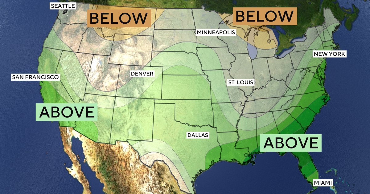
- NOAA forecasts above-average winter precipitation across the Southwest, Southeast and portions of the East Coast.
- Drought may improve in parts of the Southwest and southern Great Plains, while conditions could worsen in eastern Washington and parts of the northern Rockies.
- National Weather Service meteorologists expect below-normal snowfall across much of the northern United States, though individual snowstorms remain possible.
A strong El Niño is expected to bring a wetter winter to much of the southern United States, potentially easing drought, while warmer and drier conditions across parts of the north could leave less snow on the ground, federal forecasters said Thursday.
The National Oceanic and Atmospheric Administration’s outlook covers December through February. It points to above-average precipitation across the Southwest, Southeast and portions of the East Coast. Parts of the Great Lakes, northern Mountain West, Hawaii and much of Alaska are more likely to be drier than average.
El Niño is a natural warming of parts of the tropical Pacific Ocean that shifts weather patterns around the world. Its influence is expected to be significant this winter, but forecasters cautioned against treating the seasonal outlook as a prediction for every storm.
“A strong El Niño does not reduce the severity of winter weather risks,” said Ken Graham, director of NOAA’s National Weather Service. Wetter conditions could benefit drought-stricken areas, he said, but “too much precipitation on dry soil can fuel destructive flash floods and mudslides.”
NOAA expects drought to improve or end across portions of the Southwest, central and southern Rockies, southern Great Plains, lower Mississippi Valley and East. Western Oregon and western Washington could also see improvement, according to National Weather Service meteorologist Jon Gottschalck. Conditions could develop or worsen elsewhere, including eastern Washington and parts of the northern Rockies, CBS News reported.
Rain could carry other hazards. Weather Channel meteorologist Mike Bettes told The Guardian he expects California to face “numerous, high-impact atmospheric rivers that could bring extensive flooding and landslides this winter.” Gottschalck said Florida and parts of the Southeast should also be alert for more tornadoes this winter and early spring.
The temperature outlook favors warmer-than-average conditions across broad areas, including the Pacific Northwest, Midwest, much of the East and Alaska. Parts of the Southeast, including Florida, are expected to be near normal. Much of the Southwest has equal chances of above-, below- or near-average temperatures.
More moisture does not necessarily mean more snow. The National Weather Service does not issue seasonal snowfall predictions, but its meteorologists said much of the northern United States, including the Northeast, Great Lakes, upper Midwest and northern Rockies, should expect below-normal snowfall, The Guardian reported. The southern Rockies and parts of the Southwest and Southeast may get more snow than usual.
Private forecasts vary by location. AccuWeather expects Chicago, Boston, New York and Philadelphia to receive about half their normal winter snowfall or less, according to The Guardian. It forecasts roughly average snow for Denver, but more than last winter.
“Listen, even in the winter months, it doesn’t mean you’re not going to have snow. It doesn’t mean you might not have a snowstorm,” Graham said. “So it doesn’t erase the risk.” AccuWeather forecaster Paul Pastelok likewise warned that a single storm could change conditions for East Coast cities, particularly in late January or February.
The Guardian reported that forecasters expect the current El Niño to reach record levels this fall or winter. Graham said a stronger El Niño can make weather patterns easier to predict, but does not necessarily make its impacts stronger. MIT research scientist Judah Cohen urged caution: “We have no real historical analogue or precedent.”








Be First to Comment