Key takeaways:
- The U.S. National Hurricane Center said Polo had maximum sustained winds of 165 mph Tuesday evening; the BBC reported a Hurricane Hunter aircraft measured sustained winds near 180 mph earlier Tuesday.
- Tropical storm warnings were issued from Tecpan de Galeana in Guerrero to Punta San Telmo in Michoacán, with conditions expected early Wednesday.
- Forecasters warned parts of Guerrero and Michoacán could receive 4 to 8 inches of rain through Thursday, raising the risk of life-threatening flooding and mudslides.
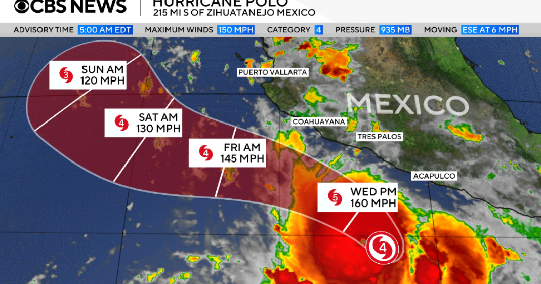
Hurricane Polo surged into a Category 5 storm off Mexico’s Pacific coast Tuesday, with forecasters warning that the “extremely dangerous” hurricane could bring life-threatening flooding, mudslides and surf to parts of southwestern Mexico even as its center remains offshore.
The U.S. National Hurricane Center said Polo’s maximum sustained winds had climbed to 165 mph Tuesday evening. The BBC reported that a Hurricane Hunter aircraft operated by the U.S. National Oceanic and Atmospheric Administration flew into the storm earlier Tuesday and recorded sustained winds near 180 mph, with stronger gusts.
NOAA’s Miami-based hurricane center said Polo’s rapid strengthening over 24 hours was “truly remarkable,” according to the BBC. Forecasters said the storm could fluctuate in intensity over the next few days but would remain a “very powerful major hurricane.”
As of Tuesday evening, Polo was positioned off the coast near Zihuatanejo, a resort city in Guerrero, and Manzanillo, a resort city in Colima. The storm had been inching northward along the Pacific coast through the morning but was roughly stationary by evening, CBS News reported. Hurricane-force winds extended up to 35 miles from the center.
The storm was forecast to make a sharp turn toward the northwest Tuesday night and Wednesday, bringing its core near the southwestern Mexican coast in the coming days. NOAA said Polo was expected to skirt the coast but not make landfall, the BBC reported.
“So far, the information we have is that (Polo) will not make a direct landfall on the coast,” Mexican President Claudia Sheinbaum said Tuesday. She warned residents along the Pacific coast to remain vigilant and pointed to Jalisco, Colima and Michoacán as states at risk.
Mexico’s government issued a tropical storm warning from Tecpan de Galeana in Guerrero to Punta San Telmo in Michoacán, where tropical storm conditions were expected to begin early Wednesday. A tropical storm watch was in effect from Punta San Telmo to Playa Perula in Jalisco, where those conditions could develop by Thursday.
Forecasters said Polo could dump 4 to 8 inches of rain across parts of Guerrero and Michoacán through Thursday, with up to 8 inches possible in some locations. Coastal areas of Oaxaca, Colima and Jalisco could receive 2 to 4 inches. The hurricane center warned that heavy rainfall “may produce life-threatening flooding and mudslides, especially in areas of steep terrain.”
Large swells generated by Polo were also expected to affect the southwestern Mexican coast for several days, creating life-threatening surf and rip current conditions.
The BBC reported that Polo is the Pacific season’s third Category 5 storm and is drawing energy from extremely warm waters linked to El Niño. Data from the Hurricane Hunter aircraft indicated Polo could still strengthen and would likely remain a Category 5 storm for the next few days because of what NOAA described as a “very conducive” environment of exceptionally warm ocean water.
Scientists monitoring ocean temperatures say the current El Niño is now the strongest on record, the BBC reported. Daily sea surface temperatures in a key region of the central-eastern Pacific were 3.05 degrees Celsius above average on Sept. 19, surpassing the previous record of 3.02 degrees set during the strong El Niño of 2015.








Be First to Comment