Key takeaways:
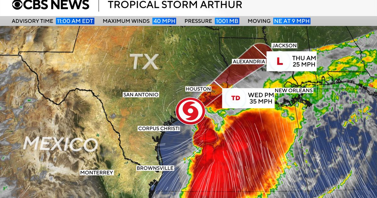
- Arthur formed Wednesday near the Texas Gulf Coast with maximum sustained winds of 40 mph, just above tropical storm strength.
- The National Hurricane Center forecast 5 to 10 inches of rain across parts of Texas, Louisiana, Mississippi, Alabama and the western Florida Panhandle, with isolated totals near 20 inches reported by NPR.
- Tropical storm warnings were in effect from High Island, Texas, to Morgan City, Louisiana, and storm surge could reach 4 feet in some coastal areas.
Tropical Storm Arthur formed Wednesday off the Texas Gulf Coast, becoming the first named storm of the Atlantic hurricane season and bringing the threat of life-threatening flooding across a broad stretch of the South.
The storm developed near the middle of the Texas coast, about 40 miles from Port O’Connor, Texas, and 190 miles from Lake Charles, Louisiana, according to the National Hurricane Center. NPR reported a hurricane center advisory placed Arthur 40 miles east-northeast of Port O’Connor. The storm was moving northeast with maximum sustained winds of 40 mph, just above the 39 mph threshold for a tropical storm.
Forecasters said Arthur was not expected to strengthen significantly as it moved toward land. The National Hurricane Center said the storm was expected to speed up while its center moved along or over coastal Texas on Wednesday, then continue into southern Louisiana and turn inland before weakening. NPR reported that Arthur was expected to move inland over southwestern Louisiana by Wednesday night and dissipate Wednesday night or early Thursday.
The main danger is water. The hurricane center warned Arthur was “expected to cause life-threatening flooding” and damaging winds in parts of the region. It forecast 5 to 10 inches of rain across parts of Texas, Louisiana, Mississippi, Alabama and the western Florida Panhandle, with NPR citing an advisory that said isolated totals could reach nearly 20 inches through early Friday along a large part of the U.S. Gulf Coast.
“Tropical Storm Arthur is expected to produce rainfall totals of 5 to 10 inches, with isolated higher totals near 20 inches, through early Friday,” the hurricane center said in the advisory quoted by NPR.
National Hurricane Center Director Michael Brennan said in an online briefing that the biggest danger would extend far beyond the coast.
“The main threat from Arthur is going to be a prolonged multi-day heavy rainfall event that could produce dangerous to life-threatening flash flooding,” Brennan said. A screen behind him showed flood watches from the Texas coast to South Georgia.
“And that heavy rainfall threat is going to persist even after the center of Arthur moves farther inland and dissipates,” he added.
Tropical storm warnings were in effect from High Island, Texas, to Morgan City, Louisiana, meaning tropical storm conditions were expected within 12 hours. A tropical storm watch was issued from Sargent, Texas, to High Island, meaning those conditions were possible within the same period.
The National Hurricane Center said storm surge could reach 4 feet above normally dry ground in some coastal areas, depending on the timing of high tide. “The deepest water will occur along the immediate coast near and to the east of the landfall location, where the surge will be accompanied by large and dangerous waves,” the center said.
Arthur also was expected to generate “life-threatening surf and rip current conditions along the northwestern Gulf Coast for the next couple of days,” forecasters said. Some tornadoes were possible.
The storm grew out of a tropical disturbance in the western Gulf of Mexico as coastal communities were already dealing with intense rain and flash flooding in multiple states. NPR reported that all of Southeast Texas was under a flood watch until 7 p.m. Wednesday, citing Houston Public Media, and that Galveston County officials urged people not to drive through flooded streets.
Arthur formed ahead of the historical average for the first named Atlantic storm. NPR reported that from 1991 to 2020, the average date was June 20, while the average date for the first Atlantic hurricane was Aug. 11.
Atlantic hurricane season runs from June 1 to Nov. 30, with activity usually peaking between August and October. Forecasters have predicted a below-average season. The National Oceanic and Atmospheric Administration’s latest outlook calls for eight to 14 named storms, three to five of which could become hurricanes. NPR reported that the recently declared El Niño is expected to make it harder for hurricanes to form in the Atlantic, while warmer ocean waters can still increase the chance of a large, destructive hurricane.


Be First to Comment